


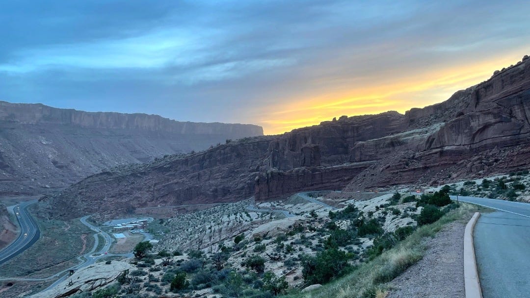
It was past sunset when I reached a fascinating point for anyone interested in geology. This is a small parking lot that anyone entering Arches National Park passes in their car, and its also a possible stop on the way down to the Visitor Centre that you can see bottom-left in the photo, with the parking lot and the string of cars leaving the park on their way to the restaurants and hotels in nearby Moab.
Unfortunately, hardly anyone stops at this point. Instead, when entering the park, everyone is eager to see the well-known rock formation of Park Avenue and quickly continues to see the famous arches. And on the way out, nobody seems to stop either because the visitors look forward to the restaurants and motels of nearby Moab after a day in nature.
And that is a pity because I can recommend taking a few minutes to stop here if you ever visit the park. Not only can you make a nice post-sunset photo like the one in this post, but it is also the best spot to see a dramatic break in the Earth's surface that occurred about six million years ago. Under intense pressure, unable to stretch, the crust cracked and shifted. Today, the highway on the left in this photo parallels this fracture line called the Moab Fault.
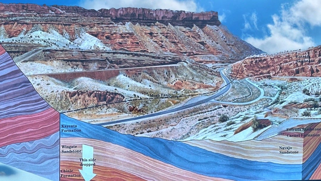
After the rock layers shifted, the canyon's east wall, from where I took this photo, ended up nearly 800 meters lower than the west side, the part across the highway. As a result of the faulting, the individual rock layers no longer line up horizontally. At daylight, the cliff across the road looks much like the Entrada Sandstone but is actually composed of Wingate Sandstone - rock deposited about forty million years before the Entrada.
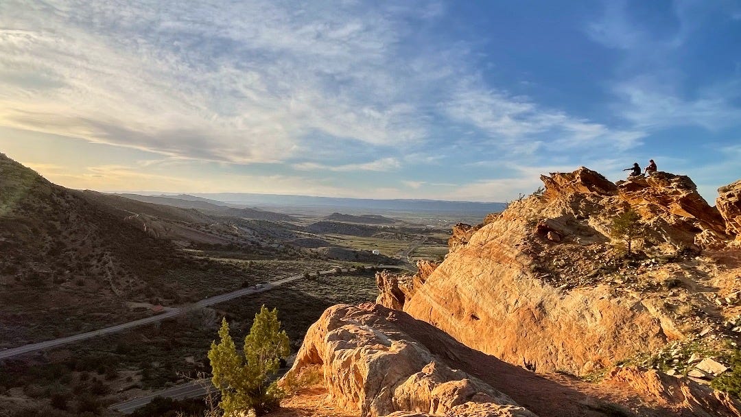
It reminded me of a similar faultline I had seen a few days earlier on the northeast side of the Colorado National Monument called the Redlands Fault. Unfortunately, just like in Arches, it was already around sunset, and although I could clearly see the faultline in nature, it doesn't show well in the photo I took.
Here is the photo of that spot:
And here is an illustration that shows the fault more clearly; the orange band shows the trace of the fault plane on the park landscape.
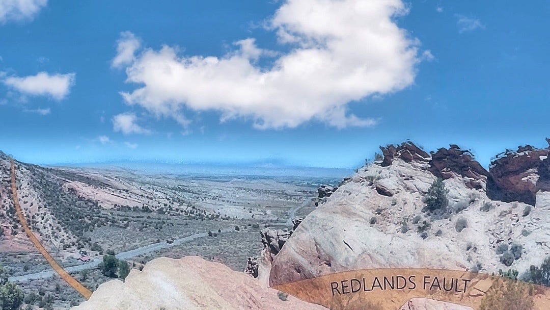
The Redlands Fault displaced and deformed these rocks between 70 and 40 million years ago. Subsequent erosion, caused mainly by flowing water, has removed thousands of feet of rock that once rose above the Grand Valley and the Colorado National Monument.
Some 80 million years ago, these sedimentary rocks were flat. But around that time, a significant plate tectonic change that would form basins and uplifts in the Rocky Mountains was just starting to compress the continent of North America. In the next 40 million years, immense forces of tectonic compression moved vast blocks of the Earth's crust vertically along surfaces like the Redlands Fault. In places where these faults didn't penetrate and break the overlying beds, sedimentary rocks were folded as they draped over the moving crustal blocks, a bit like a tablecloth will do when you push two ends toward each other.
The Redlands Fault was then exposed for millions of years as the folded rocks above it were transported away, fragment by fragment. Looking at this landscape, I was in awe, thinking of the forces required to bend and crush these rocks. It's hard to imagine the immense pressure and time it took to create these impressive geological formations. The Earth's crust is constantly shifting and changing, but on a scale that is hard for us to comprehend.
These fault lines are just a glimpse into the vastness of geological time, especially if you compare it to our time on this Earth, either as a human lifetime or even as our relatively recent presence as a species. These fault lines will remain long after we are gone, a testament to the power of nature and the enduring legacy of the Earth itself.
Perhaps, in contemplating these fault lines, we can also gain a deeper appreciation for the delicate balance of our planet and our responsibility to care for it. While our time here may be brief, we have already proven to be the most destructive species to roam the planet. But we could turn that around, focus on our responsibilities, and leave a positive mark on the world. Even if we don't manage to do so as a species, we can still do so as individuals.

Following the Colorado River: My Visit to Arches National Park.

Let me show you one of Utah's natural wonders: Arches National Park. It's one of those iconic National Parks in the American West where you feel overwhelmed by the creative power of nature. I traveled from Cisco to Moab on April 18 in the late afternoon, taking the scenic route 128. I shared photos of that spectacular journey
My visit to the National Center for Atmospheric Research
https://www.patreon.com/posts/my-visit-to-for-81532382
Grand Lake, Colorado (Alexnote)
https://www.patreon.com/posts/grand-lake-81529945
Route 128 to Moab, Utah: A Scenic Trip Along the Colorado River

Yesterday, I wrote about my dinosaur hunt in the Fruita area in West Colorado (if you missed it, click here). That afternoon I continued my journey along the Colorado River and drove via State Route 128 to Moab. It forms part of the Dinosaur Diamond Prehistoric Highway that I mentioned in yesterday's article.
« Perhaps, in contemplating these fault lines, we can also gain a deeper appreciation for the delicate balance of our planet and our responsibility to care for it. »
After all the captivating details of your article that show an extensive geological knowledge of the 🇺🇸 Colorado river region, it’s probably for being a graduated world citizen and invariably indicating our responsibility that I want to retain your above mentioned statement.
Thanks also for all your lively and embellishing photos.
Living in Los Angeles, I have both a fascination and terror of fault lines. I appreciate the beauty of the earth, the stone formations while remembering the unbelievable sound of the ground shifting below me during the 1994 Northridge earthquake...and waking up midair. Surreal.