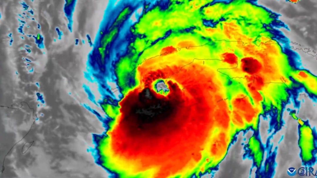
Hurricane Ian developed into a monster storm overnight. Now just 2 mph shy of Category 5 status.
Update 9:30, September 28, 2022:
Overnight, Hurricane Ian gained strength. It is now a monster storm in Category 4, and at 155 mph, it gets very close to a Category 5 hurricane. The forecasted surge near Boca Grande is up to 16 feet.
Hurricane Ian flattened homes, caused widespread flooding, and cut power to more than one million people in Cuba before moving north, setting its sights on the Florida coastline, where it is expected to make landfall south of Tampa. But it first must cross the Gulf of Mexico's warm waters, which may further fuel the hurricane.
About 2.5 million people in Florida are under mandatory or voluntary evacuation orders, and Tampa International airport closed and suspended operations on Tuesday afternoon. Meanwhile, NASA worked all night to successfully drive the 322-foot (98 meters) moon rocket to the safety of its hangar. It's just a four-mile trip, but it took all night.
In 2015, a report by Karen Clark & Company (KCC) concluded that Tampa would be the most vulnerable U.S. city during a 100-year hurricane.
"While much attention has been focused on New York and New Orleans, the Tampa/St. Petersburg metropolitan area is the most vulnerable to large losses from storm surge flooding," the report stated. "This is due to unique coastline features, local bathymetry, and the low coastal elevations." (Bathymetry is the measurement of water depth in oceans, rivers, or lakes).
The 1921 Category 3 hurricane
Speaking of once in a hundred years hurricanes, the last time that Tampa Bay took a direct hit from a major hurricane was hundred years (and 11 months) ago. In 1921, a storm that we would, by today's standards, call a Category 3 hurricane devastated Tampa when it made landfall in Tarpon Springs. The 120-mile-per-hour winds, and a storm surge of 11 feet, killed eight people, including children. The last recorded hurricane strike in the Tampa Bay Area was in 1946, but it was a minimal one.
In the past hundred years, the population of Tampa has grown from 50,000 to nearly 400,000. Many of these people live in low-lying neighborhoods that are highly susceptible to storm surges and flooding. While Hurricane Ian approaches over the shallow waters of the Gulf of Mexico, it is likely to bulldoze enormous amounts of water up into shallow Tampa Bay, which will likely inundate homes and businesses. Add to that the inches of rain that could fall during the storm.
Landfall is expected late afternoon on Wednesday between Tampa and Fort Myers. The latest forecast from the National Hurricane Center in Miami predicts a storm surge of up to 8 feet in Tampa Bay and 20 inches of rain as Ian crosses the state toward Daytona Beach. The storm surges could be as high as 12 feet in the area where Ian is expected to make landfall.
Climate change impacts
And then there is, of course, the impact of climate change. Higher water levels because of sea level rise will contribute to a higher surge. Climate change also impacts the intensity of Hurricanes. In recent years, a higher proportion fell into Category 4 and 5, a trend that is expected to continue.
Climatologist Professor Michael E. Mann explained in Salon that these storms are, on average, 20-30 percent more intense and destructive because of the roughly 1C (2F) warming of the oceans. They also produce as much as 30 percent more rainfall.
Hurricane Ian's financial damages are forecasted to be worse than those created by Andrew, which hit Florida 30 years ago, and are expected to range from $60 billion to $70 billion. If this projection by Chuck Watson, a disaster modeler with Enki Research, proves to be correct, Ian would become the sixth-costliest U.S. hurricane.
Typhoon Noru in Vietnam
Wednesday may go into history as a particularly fateful day of extreme weather events. While Ian is expected to make landfall in Florida, Typhoon Noru will most likely hit Vietnam as one of the most powerful storms to strike the country in 20 years. Scenes are similar to those in Florida on the other side of the planet: airports are closed, and people evacuate. Noru first created widespread destruction in the Philippines, just like Ian hit Cuba on its way to Florida. But the wind speeds of Noru are far worse than Ian, possibly 183 km (114 miles) per hour.
Hurricane Fiona in Puerto Rico and Canada
Meanwhile, In Puerto Rico, an estimated 503,000 homes and businesses are still without power after Hurricane Fiona hit on September 18. The storm then hit the Dominican Republic, turned north where it followed a path over the warm waters of the Gulf Stream, and hit eastern Canada this weekend. In Channel-Port aux Basques, N.L., waves came in over 12 meters. They probably broke over 16 meters, according to Doug Mercer in the Globe and Mail, a meteorologist and forecaster with the Canadian Hurricane Centre in Dartmouth.
Notes:
https://www.fox13news.com/weather/when-was-the-last-time-a-major-hurricane-struck-tampa-bay-in-1921
https://www.insurancejournal.com/news/southeast/2015/09/15/381499.htm


Unfortunately Florida is currently run by a climate crisis denier who’s also preoccupied with his Nov 8 governor re-election and 2024 presidental run. Doesn’t make a good scenario for Florida residents. Thank you for the background history of hurricanes in this area.
Thank you, Alexander, for this Florida hurricane history. By now, local people must know about the dangers involved (Modern-day Newscasting). I hope they can find their way out in time. I think, we must learn not to live in risky areas, anymore. They live there forewarned and still . . . are willing to bear/take the brunt! Protective Seawalls are not a thing of the past . . .