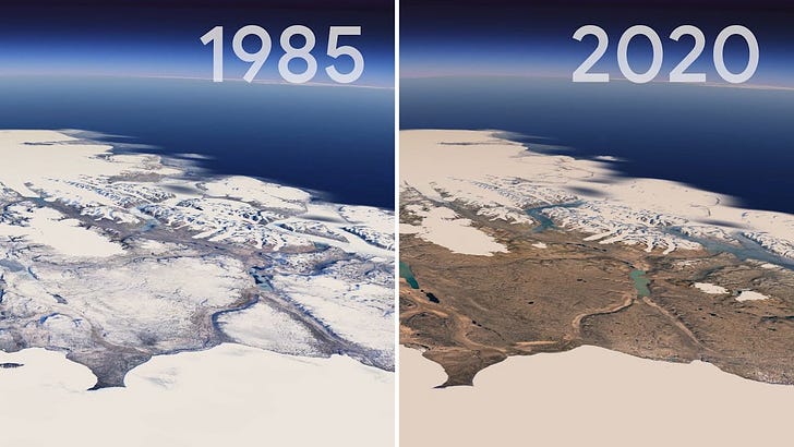
Google Earth Timelapse, and stories to watch this week.
And a special one-day-only offer of 20 percent discount
Please make use of the special one-day-only offer: 20 percent discount on this year's annual subscription to The Planet newsletter.
I am happy with the many signups for the free emails of this newsletter. But it is only possible to keep The Planet free for all if some people are willing to subscribe to the paid version. More paid subscribers are needed, hence the one-day discount possibility. It is also a birthday celebration for this now one-month-old newsletter. I want to thank you for all the support that I received.
If you like to start your day with The Planet, you can subscribe in less than a minute; this button leads to the discount offer.
Google Earth Timelapse
Do you remember the opening of Saturday's article in The Planet about the Great Barrier Reef? It started with the National Weather Service station in Chatham, on Cape Cod, Massachusetts. Increasingly intense storms had eroded that land, and they, therefore, had to abandon the station.
I thought of that story when I was looking at the updated version of Google Earth. I am a geographer, I love history, and I am fascinated by how Google Earth has managed to add the element of time to their geographical data. The first thing that you will notice on their time-lapse maps is how humans have changed the planet, for instance, in land use and by the impact of climate change. Have a look at this video; at about 48 seconds, you see the changes that have shaped Chatham at Cape Cod, the site of the weather station, over the past decades.
You can check for any place on the planet how the environment, and the local geography, have changed. Click here to go to Timelapse in Google Earth. Try, for instance, to type in the name of your city or village on the top left. I just tried it for the Dutch island where my home is and learned how the sandbanks close to the coast have moved over the years. I am sure you will notice changes too, like increased urbanization, more land taken into agricultural use, or new infrastructure.
The update of Google Earth involved 24 million satellite photos from the past 37 years. Some of the most striking changes involve glaciers, ice caps, lakes, and rivers. On the left of the screen, you see some examples. You can watch the retreat of the Columbia Glacier in Alaska, the drying up of the Aral Sea, or the urban growth in Dalian, China. I typed in Page, Arizona, to see the reduction in the available amount of water over the years.
Stories to watch this week
Ingenuity’s first flight on Mars
This Monday morning, Nasa's Ingenuity Mars Helicopter will make its first attempt to fly in Mars' thin atmosphere. You can follow the live coverage via the Twitter account of @NASAJPL or go to this website. Tune in at 6:15 am ET (10:15 am UTC, and 12:15 in most of Europe). At that time, the NASA team expects to receive the first data and hopes to confirm that they made history.
I recently wrote the post 'Eight things to know about the Ingenuity Mars Helicopter.' You can find that article here.
Earth Day
Thursday 22 April is Earth Day. The main story to watch is the Biden Administration's initiative for the Leaders Summit on Climate on 22 and 23 April. It is a virtual summit and will be live-streamed for public viewing.
Typhoon Surigae
The Philippines seem to have narrowly escaped the extreme typhoon Surigae. It is the first time that such a strong typhoon is seen this early in the year in the Northern Hemisphere. The top wind speeds are around 300 km/h.d


Climate change increases extreme weather, and the Philippines faces a scary future. Last year, 21 typhoons hit the country; their destructive power increases, while their paths are difficult to predict. In the same article of last Saturday on the Great Barrier Reef, I wrote about the absorption of heat, trapped by the greenhouse effect, into the oceans. That is not only bad for the corals and other maritime life, but it also helps to give tropical typhoons more energy. The atmosphere is also warming, about 1,1 degrees Celsius so far. And with every degree rise, the air can hold about 7 percent more water vapor.
That is a worrying combination of stronger typhoons, higher storm surges, and heavier rainfall dumped during these typhoons. Eighty percent of the Philippine population lives within 50 kilometers of the coastline, a coastline that is already dealing with the impact of sea-level rise. It will be a sad story to watch in the years to come, and it is directly related to the climate summit of this week. We know the causes, and we know what action is needed to halt climate change. The question is mainly about the political will of the world's leaders to take action.
Don’t forget to subscribe, only today there is 20 percent discount for this year’s subscribtion.
Notes:
https://www.cnn.com/2021/04/15/tech/google-earth-timelapse/index.html
https://blog.google/products/earth/timelapse-in-google-earth


I'm up to watch Ingenuity (-:
Living on an island we see constantly what the ocean can do to a shoreline. We see how the sand shifts every year and beaches are lost. Thanks for sharing Google Earth Timelapse. It is really shows how the land we live on has changed.